
The mobility and spatial operations platform for Hong Kong
Modular software for transport operators, parking managers, government departments, and enterprise teams.
Built from real mobility and parking operations in Hong Kong.
Product Modules
Six modules that cover fleet dispatch, parking, telematics, vision, spatial data, and local intelligence.
StationsOS
Dispatch, booking, and parking vacancy orchestration for on-demand mobility services.
- 509+ live parking vacancy feeds
- Booking and payment workflow control
- WhatsApp + push notifications
FleetOS
Fleet management portal with telematics integration, hardware provisioning, vehicle lifecycle, and operational workflows.
- Telematics hardware onboarding
- Vehicle lifecycle and compliance tracking
- Driver and fleet billing workflows
DataStream
Real-time data pipeline for device telemetry, MQTT ingestion, and operational event streaming across fleets and sites.
- MQTT broker with device provisioning
- Real-time telemetry ingestion and routing
- Event stream processing and alerting
AI Vision
Computer vision pipeline for site monitoring, occupancy verification, and event-based alerting.
- YOLOv8 real-time detection
- Multi-camera RTSP operations
- Event alert workflow
Spatial Intelligence
Digital twin API, indoor mapping, and pedestrian network data for planning and operations.
- 701 venues mapped
- 467K+ route segments
- GTFS transit integration
MediaOS
Agentic data collation across media categories — structured, organized, and maintained for institution-grade consumption with secure AI tooling.
- Automated SQL schema design and maintenance
- Multi-source media ingestion and structuring
- Secure AI agents for data governance
Google Maps Platform Innovators
Aircity is a recognised member of the Google Maps Platform Innovators program — awarded to organisations that demonstrate advanced implementation of Google Maps APIs in production systems.
Earned Dec 2024Solutions by Sector
Defined delivery scope for public institutions and enterprise operators.

For Mobility Operators
Fleet operations, dispatch governance, telematics, and transaction control in one stack.
- Real-time fleet status and exception monitoring
- Dispatch decisions with carpark vacancy context
- Integrated booking, payment, and auditable records

For Carpark Operators
Carpark occupancy operations, access flow, navigation, and revenue control.
- Live vacancy data across 509+ carparks
- Indoor wayfinding linked to service operations
- Computer vision occupancy verification workflow

For Real Estate Managers
Building operations intelligence, spatial analytics, and tenant-facing mobility services.
- Digital twin context for building and surrounding assets
- Operational monitoring for security and people flow
- Structured media intelligence for institutional reporting
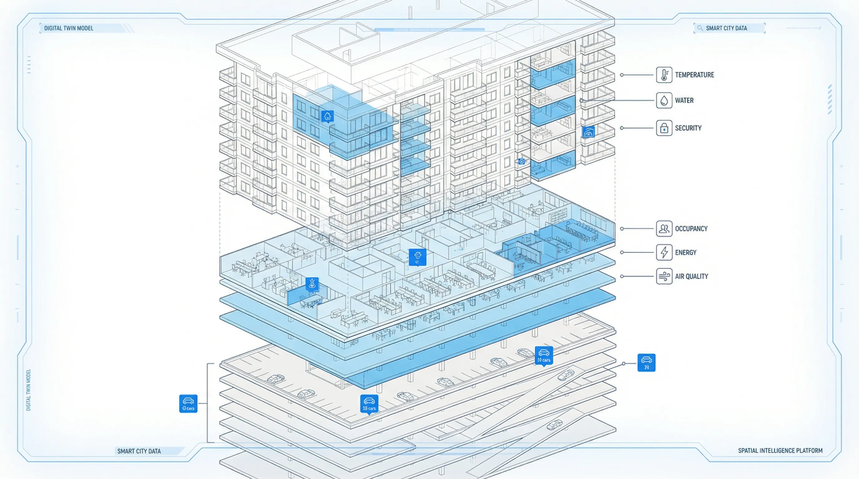
The Harbourside Tower 1
This digital twin view links each building to mobility operations, carpark workflows, and site-level analytics.
Dissected Building Ontology
Every building is modelled as a structured asset — decomposed into operational layers for parking, commercial, residential, and infrastructure systems. This ontology powers spatial queries, occupancy logic, and cross-module coordination.
GTFS API for Operational Planning
Real-time GTFS feeds are integrated into product modules for route planning, service design, and location intelligence.
Bus
0 routes
Hong Kong Operational Data Advantage
Our platform is informed by daily mobility and carpark operations in Hong Kong. Datasets are maintained for production use across dispatch, planning, monitoring, and decision support.
Plan your deployment with Aircity
Request a briefing, a demo, or a technical consultation for your department or organisation.